
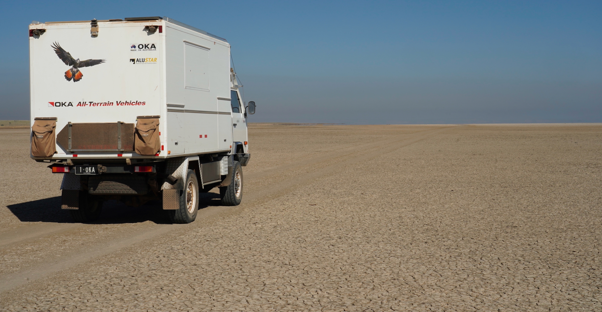
Only a week since my last post …… boy it feels more like a fortnight, we seem to have fitted a lot in to a short space of time, & have camped in 7 different spots (including tonight) in 7 days.
Firstly an update on our temperature gauge problem. I remain confident that we don’t have a temperature problem per se, just a temperature reading problem. Redarc were very good & responded to my friday evening email by phoning me first thing on Monday. The possibility I & various Burnie professionals had missed was the possibility of a poor connection at the rear of the gauge. Redarc provided me with the necessary info to check this out, but I will wait until we are somewhere I can work under cover to do so. To say that the Tassie weather has been very changeable is an understatement – 4 seasons in one hour at times! As it is I am increasingly confident that the problem is simply a loose plug, as I have been able to observe what appear to be bumpy road induced temperature fluctuations over the past couple of days.
And so on to our explorations of this drizzly, green & stunning island state. 🙂
Sisters Beach is another small holiday house hamlet just along the coast from Boat Harbour Beach, not quite as pretty & perhaps a little more downmarket, but nonetheless it provided us with a little walking practice, taking our leg muscles by surprise & giving them a warning of what was to come over the next week. A walk up the steep cliffside path to a cave afforded us a vantage point for views back over Sisters Beach, as well as into the previous Boat Harbour Beach bay.

After our walk (& indeed a week of flannel washes interspersed with ‘wet wipes’) we were in need of a shower. Our plans to have had one in Burnie had been foiled by a combination of the temperature gauge issue taking priority & Burnie’s exceptionally poor (non existent) long vehicle parking in proximity to the public showers or swimming pool. We were thus becoming increasinly concerned about the cloud of blowflies constantly circling us & the fact that most Tasmanians chose to walk on the other side of the street. 🙂 Just joking, but we did feel in need of a shower, & after a few phone calls, including one to a caravan park in Stanley where they were kind enough to offer us a shower for $10 each…… EACH! ( “They’re ‘avin’ a bleedin’ laugh” I said. “They certainly are m’dear” replied Mrstea). We found another pleasant little park on the highway where they were happy for us to have a lovely hot scrub for $1 each. Thus we were able to enter Stanley feeling a little more human & without fear of offending some old friends (also travelling) who we hadn’t seen in a while.
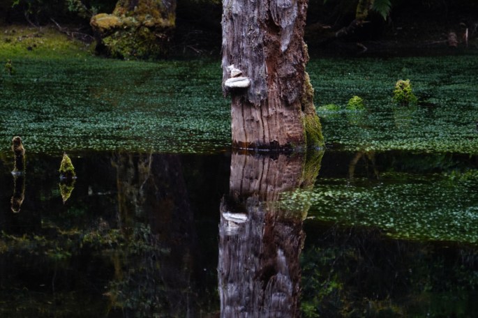
Before Stanley however we gave ourselves a night in the bush, a sheltered respite from the constancy of the wind coming in off the sea. The location was a lovely spot about 15kms inland, close to Mawbanna, a secluded & hidden grassy forest clearing along side a river. Accessing it involved a river crossing which we managed without difficulty, despite initial consternation at the prospect. Determining the water depth was difficult as, like many Tasmanian rivers (that we’ve seen so far) the water was a very dark brown, stained by tannins which leach into it from forest leaves & buttongrass plains. As it was the water didn’t come higher than our door sills, but still probably the deepest we’ve yet had to ford. It felt great to be out in the bush again, to have a camp fire & to do some baking in our camp oven. In the morning we detoured via the Dip Falls to see a river cascading over two levels of basalt columns & to the aptly named ‘Big Tree’, a giant among giants.


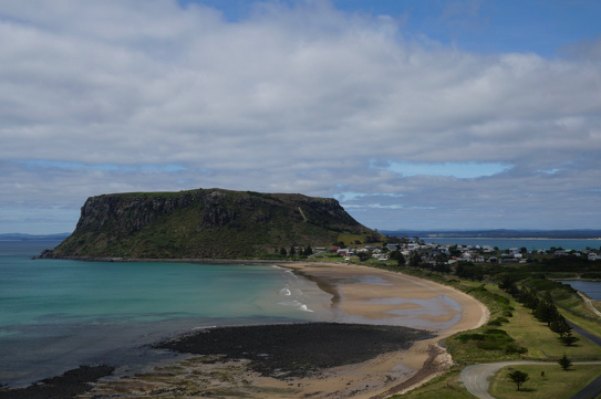
Stanley is an historic & picturesque fishing village at the end of a long narrow spit jutting out into the Tasman sea. It is still home to the small Hursey’s fishing fleet as well as being a very pretty little place. It’s outstanding feature which adds to it’s ambience is one which cannot be missed, a huge rock known as the Stanley Nut, a volcanic ‘plug’ I believe, with the village dotted around it’s base. It is possible to get to the top of the Nut by one of two methods – a chairlift or climbing a very steep & testing path. Yep…. we took on the path & conquered it both up & down, plus the 2.3km circuit walk at the top which took us through grass plains & forest & gave stunning sea views as well as over the town & the spit. Our legs surprisingly didn’t complain as much as we’d expected them to. Having caught up with our friends afterwards & set up camp with them for the evening, we felt it fitting to reward ourselves with a feed of fresh fish from Hursey’s fish & chip shop at the harbour. The generous portions were enjoyed both by us & the large crowd of Silver Gulls as we scoffed them in the leeward side of a convenient wind break outside the shop. After a slow wander around the town a short drive afforded us some good views of the town, it’s beaches & some strange looking birds. They looked like rather gangly chickens but clearly were not. Turns out we had stumbled across a gang of Tasmanian Native Hens, a flightless bird of the ‘Rail’ family we had previously been unaware of. Before leaving home a friend advised us that “there is something new to see around every corner in Tassie” & it is certainly feeling like that is just how it is.


West from Stanley took us through Smithton (where we stopped for a short wander, fueled up & grabbed a few supplies) along the Bass Highway to it’s end at Marrawah. It’s the only highway we’ve yet been on in Tassie, & to us is seemed little more than a narrow country road – far more preferable than any multi lane highway, but the large number of laden log trucks coming toward us did make it feel especially narrow at times, however we are finding that we are ‘acclimatising’ to these smaller roads with no hard shoulder. Turning off just past Marrawah’s Gospel church (these & similar have been noticeably prevalent along this northern coast from Devonport) toward the sea, along a lane we hoped would take us to our first view of Tasmania’s west coast. The road became a gravel one, & then a very narrow & steep gravel one. We (I) missed the turn to the beach & found ourselves at a farm gate with nowhere else to go, certainly nowhere else to turn around. The two large barking dogs beyond the gateway were a tad daunting, but there was no other option we had to risk the wrath of the farmer, as well as the prospect of being savaged by his dogs. A well executed handbrake start on the steep gravel took us into the farmyard. The dogs ran around in a barking frenzy, but were wagging their tails. As I executed a 3 point turn expecting a shotgun waving farmer to emerge from the house or a shed, instead a lady emerged. MrsTea wound down her window & called out “Sorry…. we made a mistake”.The result was a huge beam on the lady’s face & two thumbs up. We reckoned we probably weren’t the first to have made the mistake, but left once again feeling a sense of appreciation for Tasmanian friendliness.
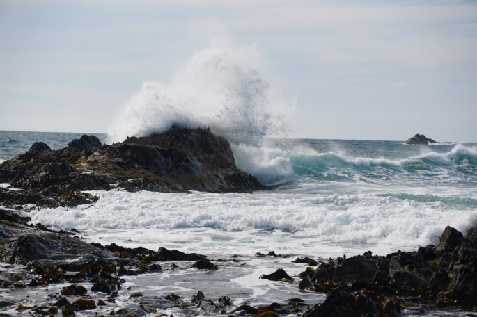
The beach consisted of large rocks & pebbles, with sand & dunes a few hundred metres away. A rocky, craggy shoreline where we enjoyed climbing, then sitting & watching the surf foaming in & through the many crevices, & observing the constant rise & fall of the thick leathery kelp attached to the rocks all around. The sun shone & had it been later in the day & less windy it would have been a great spot to camp for the night.

Instead we continued south down the west coast hoping to find a sheltered spot to spend the night. It seemed we may be out of luck, the west coast wind – all the way from Africa apparently, wasn’t going to let up. We passed through the steep estuary township of Arthur River into the Arthur Pieman conservation area, stopping at the only camp spot which was sheltered – Prickly Wattles campground. To us it seemed unattractive & too far from anything we wanted to see, so we continued southward. Another campground at Nelson Bay behind some sand dunes gave beach access, but the best spots were all taken by unoccupied ‘permanent’ camps & what was left didn’t appeal, & we continued onward. Such days tend to end up with disappointment, reaching the night’s stay only by virtue of time running out & the need to get set up. We were feeling very much like this & growing increasingly despondent at the prospect of finding a good spot in what seemed like a heavily controlled but poorly serviced coastline. Luck however, was on our side. We drove into the tiny fishing settlement of Couta Rocks, which as it turned out was a sliver of coast where the few shacks that exist are on freehold land. The prospect of camping didn’t look especially promising, but we did see a flat sheltered area & the coastal formations gave a very attractive view. We parked & had a wander around, finding one of the handful of residents who live there full time who in the course of conversation gave us his blessing to stay overnight in the spot we had ‘selected’. A case of ‘if you don’t ask, you don’t get’. Our stay saw us enjoy a west coast sunset, our first sightings of White breasted Chats, & some interesting exploration of the craggy rocks & pounding surf. We wondered how on earth the abalone & crayfish boats could safely navigate through the maze of hull ripping rocks in such seas, but were assured that there were two clear passages. Sure enough whilst laying in bed the following morning, we watched three boats picking their way out to sea for another days fishing.


From Couta Rocks it was only a few kilometres down the coast to Temma, another tiny fishing settlement & the last before the real wilderness coast begins. It’s possible to continue south from there & I was a bit tempted whilst MrsTea was a little less so. Tales of quicksand swallowing vehicles & the need to travel in a full recovery equipped convoy of at least 3 cars made it sound unwise, but I’d heard it was nevertheless possible to go beyond Temma & I fancied the idea of going as far as we could, albeit very cautiously, just to find some of this ‘car swallowing quicksand’….. without, of course, falling victim to it. I suppose it had me a bit spooked too though. Reaching the gate which said we needed a Rec Vehicle Permit, available all the way back up at Arthur River to continue on provided me with an excuse to chicken out & to go with MrsTea’s wishes. Damn those permit people! 😉
And so it was back up to Couta Rocks (no temptation to try Tasmania’s reputedly most severe 4wd track from Temma inland to Balfour – The Balfour Track. Again recommendation is to travel in convoy, + each vehicle to be equipped with a winch, a snorkel & an experienced driver….. this is an 18 kilometre ‘hard-core’ track where water is frequently above the bonnet level, & the need to winch multiple times is a given…. ummm no thanks).
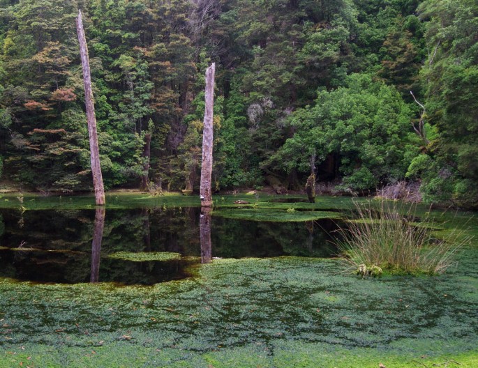
At Couta Rocks we turned west & found ourselves a short time later in The Tarkine forest. The Tarkine is a name I’ve heard for years, a wilderness area equal to any in the world as far as it’s pristine values goes. On a day when one of the headaches I occasionally get from a neck condition had gradually developed, finding that this pristine wilderness had a new sealed road running through it to give visitors & the log trucks access (yep logging is big in the Tarkine – there are signs everywhere telling you it is a ‘shared forest’, or that this is ’sustainable regrowth forest’ & in places ugly cleared hillsides with only the unprofitable timber laying on the ground in between the odd token treefern) my frame of mind was not the most positive. We had planned to camp at the Julius River Motorhome & Caravan campground. On finding the small & squeezy area, heavily populated by hungry mozzies my mood did not improve. I was feeling less than complimentary about the world renowned bloody Tarkine. A painkiller & good night’s sleep helped, as did our drive around the bitumen circuit drive the following day, especially when we were lucky enough to see a Tasmanian Devil run across the road in front of us. We did ‘the tour’ of all the ‘attractions’ around the circuit & walked all of the forest walks (with the exception of the 3 hour Balfour Walk). The quiet & peaceful walks in moss covered cool temperate rainforests among huge ‘old growth’ trees & tall ‘man ferns’ worked their magic on my mood, whilst MrsTea constanly expressed her love of treeferns. Our ‘highlights’ were a water filled sink hole beside the road & the Trowutta Arch – a natural rock arch formed by two sink holes adjacent to each other within a gorgeous forest setting.


It really wasn’t until we left the ‘Tarkine Drive’, to go south again, on the ‘Western Explorer road, down through the heart of the Tarkine Wilderness which extends for another 120+ kilometres to the Pieman River that the Tarkine took my heart. As wilderness areas go, this may not be the biggest, but it is still truly wild & largely untouched. The gravel road seemed to us far more befitting than a sealed road, & we felt very much ‘at home’ on it’s never ending ups & downs, twists & turns across the mountain range. For as far as we could see there were mountains after mountains after mountains, all covered in forest. Country as it has been for longer than anyone can remember. There were some very steep ups & downs, 2nd gear was commonly used, & 1st was essential on the steepest section. Not difficult to drive, but requiring confidence & commitment on occasion.
Of course it is not completely untouched. Apart from the road there was Balfour, a tiny tin mining settlement established around the end of the 19th century. How those folk survived in that remote location is a testament to their hardiness. Balfour today has the remnants of it’s mining heritage & two or three residents. We detoured off the Western Explorer for a few kilometres, in low ratio, hubs locked to visit the settlement, not expecting to find anyone living there, but instead searching for a small cemetery deep in the bush we had read about, containing the graves of a few poor souls who had succumbed to a Typhus outbreak in 1912. We found the graves plus two of the current residents who welcomed us. We also encontered our first Tassie snake. A ‘Tiger’ we think, whilst walking through the bush to the nearby Frankland River (1.5kms – all downhill on the way there). It was lighter in colour to those we have previously seen, & with a black head so perhaps not a Tiger. (Please let us know if you can identify it in the photo). It was blocking our path & didn’t move as we approached, so we kept our distance & lobbed pieces of wood at it. On the third piece it took notice & slithered away. We camped just outside of Balfour overnight, crawling back up the steep, narrow & rocky track back to the main track the following morning. This was probably the biggest test we’ve put on our rig to date, & found that the Patrol managed it easily & the Tvan just followed wherever we went.


The hollyhocks grow wild in large swathes around Balfour.


Many, many more rollercoaster-like kilometres on the mostly good gravel surface brought us to Savage River where we set up camp alongside the bridge, overlooking the water & had a ‘domestic’ day, getting some washing as well as a few other chores. It was quite a pleasant camp in a spot suitable only for a single vehicle. A highlight was seeing a platypus swim past whilst we were eating breakfast this morning.

From Savage River it was only about 8 kilometres to the little settlement of Corinna on the Pieman River. Although not especially wide the river here is is 100’ deep according the the single vehicle ferry operator who took us across. From the time we had turned off onto the Western Explorer road & seen the signs stating that the maximum length the ferry could carry was 9 metres our ‘plan B’ had been to turn back north east up though Waratah & Cradle Mountain, but the chap at Couta Rocks told us not to worry, that they’d take us on the Ferry. And of course he was right, the 9 metre measurement is taken from front axle to rear axle & from our car’s front axle to the Tvan’s axle came in at under the 9 metres easily, even though our total length is almost 10 metres. The ferryman was a traveller from WA who had seen the job advertised for a 3 month stint on the internet. Nice work in a great location if you can get it. We went across at around 10.30 am & believe we were the 3rd customers for the day (the other two had driven past our camp spot earlier in the morning). The whole crossing affair was very laid back, no rushing with anything, a bit of a yak & a $5 discount for cash to save walking up to the pub to use the eftpos machine.


We then headed across yet more mountains, (the Meredith Range) past flooded valleys supplying hydro electric generators, to Tullah to a free camp on the nearby Lake Rosebery, importantly one which has a phone signal available so I can get this post sent.
Tomorrow we hope to visit Montezuma falls & test our nerve on it’s long & narrow suspension bridge.
Lovely photos xxx
Definitely a tiger snake. Won’t be the last one you will see over there! We took to classifying our walks by the number of tiger snakes encountered….
The wild wild we(s)t.
Love it.
Enjoying the blog and photos.
Thanks
opps, that should read
Notechris ater
There is also the Peninsular Black Tiger
Notechris ater niger
Cuppa, yep,
There is a classification of a Black Tiger Snake. And is in Tassy.
Noyrchis ater (Kreft 1866)
I reckon I have black tigers at Taggerty.
Nice stripes on that one
Tiger snakes come in all colours and are generally bigger than Copperheads, although most times you don’t get close enough to get on a first name basis with them. Whipsnakes are only about 300mm long
Another wonderful place is Bird River, south of Queenstown. I tried to copy and paste directions here but was unsuccessful, so I’ll post to your FB page, Jan.
Couta Rocks!!! I spent a week camped there – wonderful, wild and windy place – they all have wind turbines. Had to turn the Motorhome around as I couldn’t open the door because of the wind. Loved that place it reminded me of the west cost of Scotland.
Another great post Cuppa and Mrs Tea
Foxgloves, not Hollyhocks
And yes a Rose…
Hi Marie, we had a debate as to whether they were Hollyhocks or Foxgloves ….. a google image search suggested they were one & the same thing?? Definitely a rose though! xxxx
Ian do not miss a night at Ocean beach coastal reserve from memory 8-10km west of Strahan 250m north of the beach point entry used by fisherman and where the best camping is there is a mutton bird rookery the noise and kerfuffle when they return after dark and the way they find their burrows is amazing , we were there in March but would expect they are there year round . When we were at Arthur R we stopped at Lands end near Arthur river they even had a wind break shed and tables there right at the mouth of the river lovely spot .
Hi Cuppa, glad you’re exploring the west coast. I hope you didn’t take the Tvan in to Montezuma falls! I guess you know by now the tight corner or two with cliff edges.
If you have time Trial Harbour is a beautiful place to camp, but with few Camp spots. Also Macquarie Heads camp from where you can drive along the beach several km back to Strahan’s Ocean Beach Lookout (camping spot also). Along the road back to Strahan, near the airport, in the early morning and at dusk in the knee high Heath, you may see the Southern Emu-Wren.
Keep safe! Jan and Peter.
Cuppa and Julie, enjoying your travels, wise decision on the Balfour track, we did it with the troopy and camper in tow after an extended dry period and when we did get stuck the water was up to the windows on the rear door and the camper was under, by ourselves the winch pulled us out from the tiniest tree within reach, not the first time that tree had been used either. Safe travels Peter & Sandra
Hi Cuppa and Mrs Tea,
still keenly following your blog and loving your exploits 🙂
After some further research regarding the snake, I think your first instincts were right on the money, it was a tiger snake, and I have found a few photos of black headed darker ones.
In fact Parks & Wildlife Service website has a good photo, but there is something wrong with their website and it won’t open correctly for me.
Keep having fun kids 🙂
Tiger snake Cuppa , there black down there .